With the increase in online orders from consumers and the corresponding supply chain pressure put upon suppliers, our roads have never been busier with the transportation, collection, and delivery of products and services. It is therefore essential that both company and driver are ensuring that every second spent on the road is done so as safely as possible.
Seemingly minor road incidents can often result in traffic build-up that requires drivers to heavily reduce their speed and suddenly decelerate from as fast as 60mph (96km/h) to less than 10mph (16km/h). For even the smallest of vehicles this can be very dangerous, especially without sufficient warning. So given the sheer size and weight of larger commercial vehicles, you can imagine the heightened risks sudden slow down brings.
Unfortunately, such traffic-causing incidents sometimes come out of nowhere and can regularly lead to secondary motor vehicle accidents such as damage to other vehicles, as well as more seriously, injuries (or even fatalities) to other road users.
Additionally, from a business perspective, traffic incidents frequently lead to time being wasted and deliveries being missed as the driver is often stuck and unable to go anywhere, albeit slowly; Impacting both customer satisfaction and the associated operational costs of the business.
In order to help keep drivers and fleets safer, whilst optimising company operations to save on time and costs, Trimble MAPS offers a Traffic solution available through an add-on license that can be applied to our commercial navigation software CoPilot!
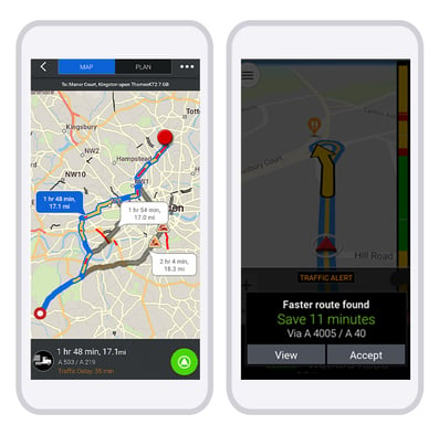
Our Traffic data provides full visibility of the traffic information on planned routes and gives timely alerts to drivers whilst on the road - prewarning them of unexpected traffic incidents ahead and giving them enough time to safely slow down. Our Traffic solution also provides alternative routes for drivers to go on which will avoid the traffic incident, along with the potential delays it has likely caused, completely.

How exactly our Traffic solution works
Using historical and real-time (live) traffic data a route is created. Our technology then intelligently overlays traffic information to provide the best and safest route options to the final destination - giving precise travel times to drivers and accurate ETAs to customers.
Live traffic data is used for the first 60 miles (96 km) of a route to measure initial travel times, while historical traffic speeds are used for the remainder of the route. This is to account for traffic fluctuations that may occur after this distance.
During the trip, approximately 5 miles (8 km) before any unexpected traffic incident, the driver is warned to slow down. The slowdown warning alert is available for large commercial vehicles (Heavy, Medium, Light Duty, and Bus vehicle types) when the driver selects their vehicle profile.
.gif?width=500&name=Newsletter%20images%20(12).gif)
Need further information?
For more extensive details on how our Traffic add-on works, please refer to our features guide. Also, why not check out our new infographic 5 Reasons Traffic Data is Important?
If you would like to discuss anything further with a member of one of our experienced regional teams, please complete the form below!
