
When it comes to navigating on the road, we’re used to opening a mobile app and expecting it to quickly route us from Point A to Point B. We love the convenience, the speed, and the accuracy. But if you drive a commercial vehicle for a living, the road and the means by which you navigate it can look very different. Suddenly, the consumer-grade navigation app you depend on in your personal time harbors some major shortcomings that can lead to time wasted, wages lost and safety jeopardized when you’re behind the wheel of a ten-ton truck.

Carriers, shippers and the drivers they depend on to keep freight moving need to take into consideration a wide range of challenges that your typical commuter (and their app) simply does not. In the article below, we’ll explore how practical obstacles, legal restrictions and safety concerns make it essential for commercial transportation and logistics organizations to use maps and navigation tools purpose-built with them in mind.
Why Do Commercial Vehicles Need Special Maps & Navigation?
From the back office to the driver’s cab, the challenges commercial operations face on the road are numerous. Overcoming those challenges depends on information that is collected and presented in a way that understands what commercial drivers need to know to safely and efficiently deliver their cargo.
On one hand, there are physical and logistical challenges tied to characteristics of the truck being driven, the loads being hauled and the conditions on the road. For instance, different vehicle dimensions can limit which roads different trucks can travel without fear of crossing lines, striking a bridge or encountering dangerous intersections. Speed limits or detours can severely impact the carrier’s ability to meet ETAs. And inadvertently traveling roads built with strict weight tolerances might put a commercial driver and those around them at risk should their heavily laden vehicle exceed the limit.
On the other hand, countless legal restrictions and regulations can create a complex web of requirements that only commercial maps and navigation tools can accommodate. US federal regulations, for example, dictate that a driver cannot exceed more than 14 consecutive “Hours of Service” on the road, so as to limit the possibility of fatigue and dangerous impairment. Commercial drivers are required to avoid truck-restricted roads that prohibit oversized vehicles for fear of putting other drivers or themselves at risk. Failure to obey the rules can cost a business thousands in fines, from a few hundred for drivers to tens of thousands for companies. When every minute counts and safety’s top of mind, it’s vital the route planned for a commercial driver is the most accurate it can be.
How Are Commercial Maps & Navigation Tools Different?
Simply put, commercial maps and navigation tools differ from consumer-grade products because they factor in the physical risks and regulatory considerations described above. There are numerous attributes of the vehicles, their loads and their routes, including:
|
|
When these parameters are taken into account, routes from the same location to the same destination can differ greatly for commercial vehicles using maps and navigation tools built for them, as opposed to those built for typical drivers. For instance, a route from Philadelphia to Washington, D.C. will change drastically in the roadways around the destination due to restrictions around the nation’s capital.
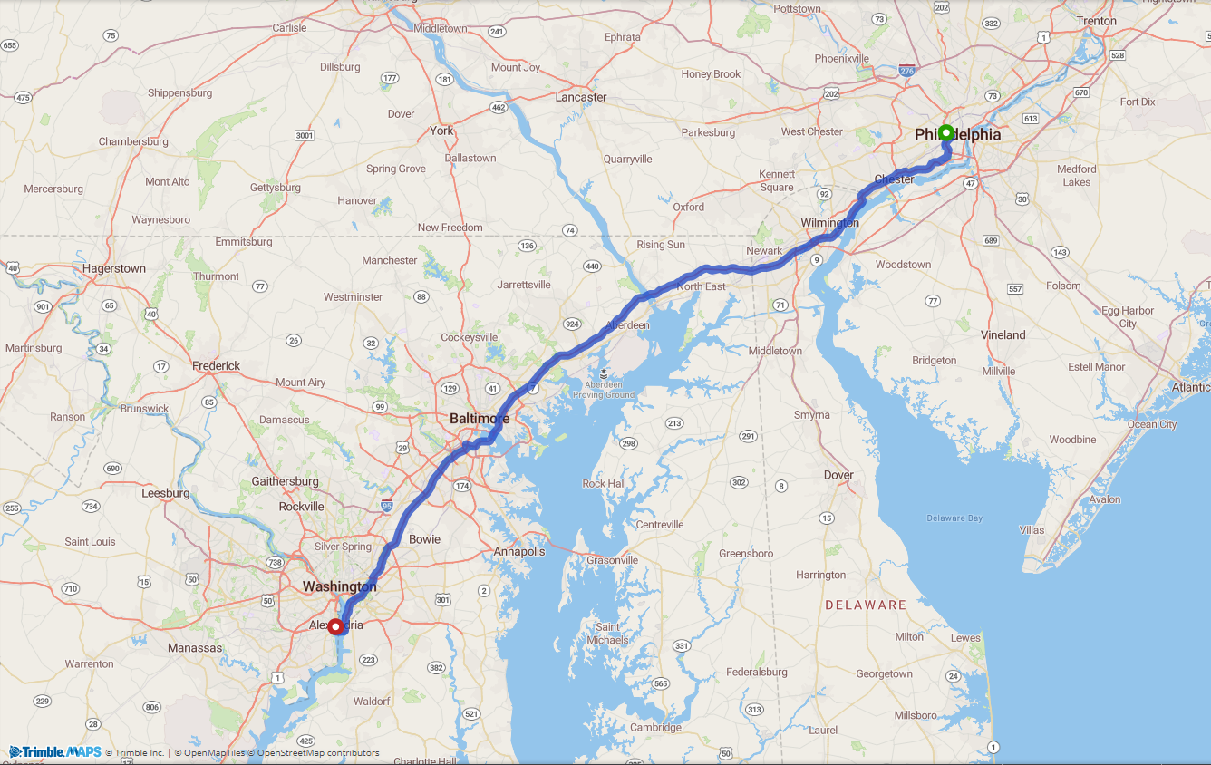
Route calculated for a standard automobile. |
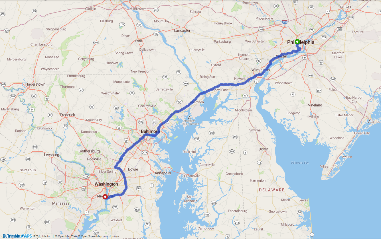
Route calculated for a commercial truck based on road attributes and restrictions. |
Fine tuning these maps and tools isn’t easy. Trimble MAPS, for example, employs a team of hundreds of GIS and map data specialists to make hundreds of daily adjustments to roads based on roadwork, closures, regulations, the addition of new roads, and more. We even go so far as to outline thousands of potential destinations in boundary polygons. These “geofences” make it easy to see when a truck’s GPS has passed into or out of a location, so the company and its customer can quickly be notified of arrivals and departures. Plus, we include location entry and exit gate information in our commercial maps, so drivers can travel the safest, most efficient route down to the last mile and into their destination’s entrance.
What Are the Major Benefits?
Using the right maps and navigation tools can lead to a cascade of advantages and benefits for carriers and their drivers. First, these purpose-built resources help ensure drivers’ safety where consumer-grade products cannot. By taking into account a vehicle’s dimensions, road restrictions, and load and planning a route accordingly, carriers are able to better avoid the maneuvers and circumstances that put their drivers at risk. Plus, these tools take into account the regulations designed to keep drivers and their cargo safe.
Second, the right data and navigation can increase operational efficiency and improve ETA prediction by ensuring a vehicle’s route is calculated based on actual, truck-legal roads. This saves time and money and improves resource usage, allowing more deliveries to be made, miles to be tracked more accurately, and drivers to be more satisfied with their work. Routes planned with consumer-grade tools for typical automobiles might take longer than they can accurately predict for commercial vehicles, resulting in unpaid miles, delayed arrivals and frustrated customers.
And ultimately, these benefits combine to deliver an improved experience for those customers. When their routes are built on the most accurate maps, carriers can collect better data and gain valuable insights into potential operation improvements. When drivers are guided by tools that understand the challenges and priorities they face, they’re better equipped to drive safely and efficiently. And while we all love the convenience of mobile apps, when it comes to commercial transportation and logistics, the right maps and navigation tools help everyone on the road or waiting for a delivery.
This article was also featured in Outbound Magazine and appears courtesy of Trimble Transportation.