
Transporting hazardous materials along illegal routes not only poses serious public safety, driver safety, and environmental concerns, but can also carry quite a hefty fine. A US trucking company found that out the hard way in 2019 when they pled guilty to an illegal hazmat transport, resulting in $3 million (USD) in penalties and environmental remediation.
Ease the Burden of Hazmat Compliance
There are various guidelines issued by the National Hazardous Materials Route Registry, as well as parallel legislations throughout Europe such as the ADR. With the amount of hazmat compliance information out there, it is no surprise why carriers can struggle with finding safe and compliant routes.
With the Trimble MAPS portfolio of solutions, we can help you plan in accordance with the Department of Transportation, nationwide hazmat, and nationwide dangerous goods regulations globally.
Plan with Routing Restrictions
Not all hazardous materials are the same - routes can vary based on the type of material being transported. By using an advanced routing software that includes hazmat road classes and routing categories, you are able to get accurate mileage and distance calculation on roads which are identified as being both safe and legally compliant.
Here is an example of a route with the same origin and destination - one route using hazmat restrictions and one without.
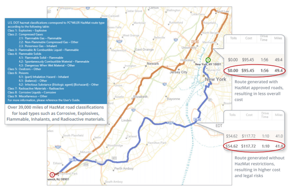
By easily comparing standard mileage and hazmat mileage, carriers can better estimate actual operating costs when negotiating a rate.
Not only is it important for back office operations and accounting to have precise, safe routing and mileage, but it’s vital to provide drivers with those same detailed, turn-by-turn, hazmat-compliant driving directions.
Navigate Safely and Reduce Risks on the Road
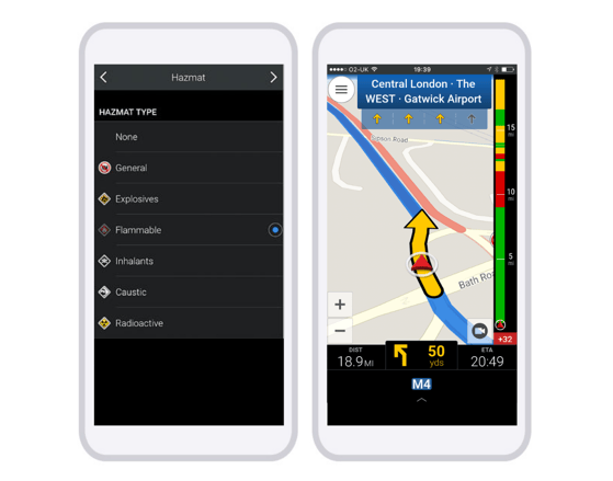
Give drivers the confidence they need when transporting these loads by using in-cab navigation that routes and navigates based on hazmat road restrictions. Simply ensure drivers are changing their vehicle and routing profiles to select the appropriate hazmat classification and/or load type prior to running the route.
Depending on the values you select for those parameters, the routing algorithm will generate legal and safe routes by avoiding or favoring certain types of roads:
- Favor = routing will prefer these segments
- No change = routing will not be altered in any way
- Avoid = routing will go around these segments whenever possible
- Discourage = a lesser degree of avoidance, used when a state or road authority allows hazmat only at certain times of day, with prior notification, by permit, or in limited quantities, and for tunnels not otherwise classified
Discover the different Hazmat Route Options and Road Categories that are considered within Trimble MAPS routing algorithms.
Road restrictions are constantly being updated and may be different depending on the map version being used in any back office or navigation software. It is recommended that map data on devices is updated annually. For additional safety, drivers should be reminded that local signs and restrictions should always take precedence.
Comprehensive Hazmat Solutions
Whether you need back office routing software or in-cab hazmat solutions, we’ve got you covered. PC*MILER offers hazmat routing in both its desktop and web-based application; CoPilot Truck provides voice guided navigation to drivers through many telematics providers as well as a standalone app; and MileOn by PC*MILER allows drivers to plan trips using hazmat restrictions.
If you would like more information, complete the form below and speak with a member of our expert team!